Research Roundup: Destruction of a coastal volcanic cone by waves in western Faial, Azores
Research and impact 21st September 2020
PhD student Zhongwei Zhao’s research has revealed how erosion by waves is destroying a volcanic cone in the Azores, first quickly and then more slowly. We highlight two recent publications that Zhongwei has contributed to, with implications that include the possibility of predicting erosion trends and the creation of shallow banks and guyots in reef‐less mid‐oceanic archipelagos.

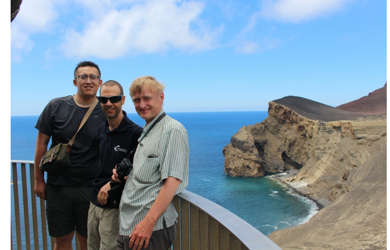
Photograph of southwest Capelinhos coastal cliffs, view SE towards NW. Note the layers of volcanic particles dipping landward (to the right) with steep gradients up to 30°, becoming nearly horizontal towards the easterly edge of the photo. (From left to right are Zhongwei Zhao from UoM, Dr Rui Quartau from Portuguese Hydrographic Institute and Dr Neil Mitchell from UoM).
Coastal erosion is becoming a problem where soft materials make up the cliffs, including around parts of the UK, but how more rocky coasts change is less well known because erosion there is slower. My PhD has involved studying a coastal volcanic cone in the Portuguese Azores islands, which grew during a violent eruption in 1957 and 1958. There, the erosion is “sped up” because the cone is exposed to powerful Atlantic storms. The site, Capelinhos, is famous in Portugal as a proposed UNESCO World Heritage Site and because the eruption led to a large evacuation of people from the Azores to the United States (assisted by a young senator, John F. Kennedy). I visited Capelinhos in 2017 with Dr. Rui Quartau from Portuguese Hydrographic Institute and Dr Neil Mitchell from UoM and found it to be a desolate, almost Martian, landscape of volcanic ash and lava but beautiful, with dramatic seascapes.
The Capelinhos volcano formed in what is called a “Surtseyan” eruption, named after the island of Surtsey, which formed near Iceland as a result of a submarine eruption. In such eruptions, the hot lava and ash explode in contact with seawater. Hence, the original Capelinhos cone was a mixture of weak volcanic ash and stronger lavas. It has been frequently subjected to extreme waves that can sometimes exceed 16m in height. I used historical aerial photos to study how wave erosion modified the coastlines of Capelinhos immediately after its formation. The coasts were found to have retreated at a rate of up to ~326m/yr, a half year after the eruption, which is one of the fastest known coastline retreat rates to date. But then erosion rates decreased dramatically to only ~2m/yr in recent years. This partly was caused by waves approaching the cliffs losing some of their energy crossing a submarine platform that has been left behind by erosion. Erosion has also slowed because the remaining cliffs are stronger (lavas and “fused” ash) and they are armoured by large blocks, much like large blocks of rock or concrete are used to protect harbours. This study has been the first to reveal the early stage evolution of Surtseyan volcanoes both on land and under water. If the coasts of the volcano continue to be eroded as they have been, I predict it will sadly disappear by A.D. 2118.
The work has continued with a study of coasts of lava of known age in three different oceanic regions (Hawaii, Azores and Ascension Island). We can tell from features on the seabed where the lava coasts originally extended to. Surprisingly, the erosion rates appear to bear no relation to the strength of waves reaching them, so we suspect that erosion depends instead mainly on the strength of the rocks and how fractured they are. Beware if you are considering buying cliff-top properties on coasts of old lava!
Article Abstract
Erosion of volcanic islands ultimately creates shallow banks and guyots, but the ways in which erosion proceeds to create them over time and how the coastline retreat rate relates to wave conditions, rock mass strength and other factors are unclear. The Capelinhos volcano was formed in 1957/58 during a Surtseyan and partly effusive eruption that added an ~2.5 km2 tephra and lava promontory to the western end of Faial Island (Azores, central North Atlantic). Subsequent coastal and submarine erosion has reduced the subaerial area of the promontory and created a submarine platform. This study uses historical information, photos and marine geophysical data collected around the promontory to characterize how the submarine platform developed following the eruption. Historical coastline positions are supplemented with coastlines interpreted from 2004 and 2014 Google Earth images in order to work out the progression of coastline retreat rate and retreat distance for lava‐ and tephra‐dominated cliffs. Data from swath mapping sonars are used to characterize the submarine geometry of the resulting platform (position of the platform edge, gradient and morphology of the platform surface). Photographs collected during SCUBA and ROV dives on the submarine platform reveal a rugged surface now covered with boulders. The results show that coastal retreat rates decreased rapidly with time after the eruption and approximately follow an inverse power‐law relationship with coastal retreat distance. We develop a finite‐difference model for wave attenuation over dipping surfaces to predict how increasing wave attenuation contributed to this trend. The model is verified by reproducing the wave height variation over dipping rock platforms in the UK (platform gradient 1.2° to 1.8°) and Ireland (1.8°). Applying the model to the dipping platform around Capelinhos, using a diversity of cliff resistance predicted from known lithologies, we are able to predict erosion rate trends for some sectors of the edifice. We also explore wider implications of these results, such as how erosion creates shallow banks and guyots in reef‐less mid‐oceanic archipelagos like the Azores.
Zhao, Z., Mitchell, N. C., Quartau, R., Tempera, F., & Bricheno, L., 2019. Submarine platform development by erosion of a Surtseyan cone at Capelinhos, Faial Island, Azores. Earth Surface Processes and Landforms, 44 (15), 2982-3006. Doi: 10.1002/esp.4724.
Zhao, Z., Mitchell, N. C., Quartau, R., Ramalho, R.S., & Rusu, L., 2020. Coastal erosion rates of lava deltas around oceanic islands, Geomorphology. Doi: 10.1016/ j.geomorph.2020.107410.
aerial photographyAzoresbanksCapelinhoscoastline retreaterosionguyotslava coastsrock mass strengthsubmarine platformSurtseyan volcanoeswave conditionswave erosion


Leave a Reply